
Turbidite........................................................................................................................................................................................................................................Turbidite
Turbidito / Turbidita / Turbidit / 浊流沉积 / Турбидит / Torbiditici /
Deposit setted from gravity currents that transport sedimentary particles* of very varied sizes. One of the main features of these deposits is that they exhibit a fining upward stratification.
See: « Submarine Basin Floor Fan »
&
“ Submarine Slope Fan ”
&
« Lowstand Systema Tract »
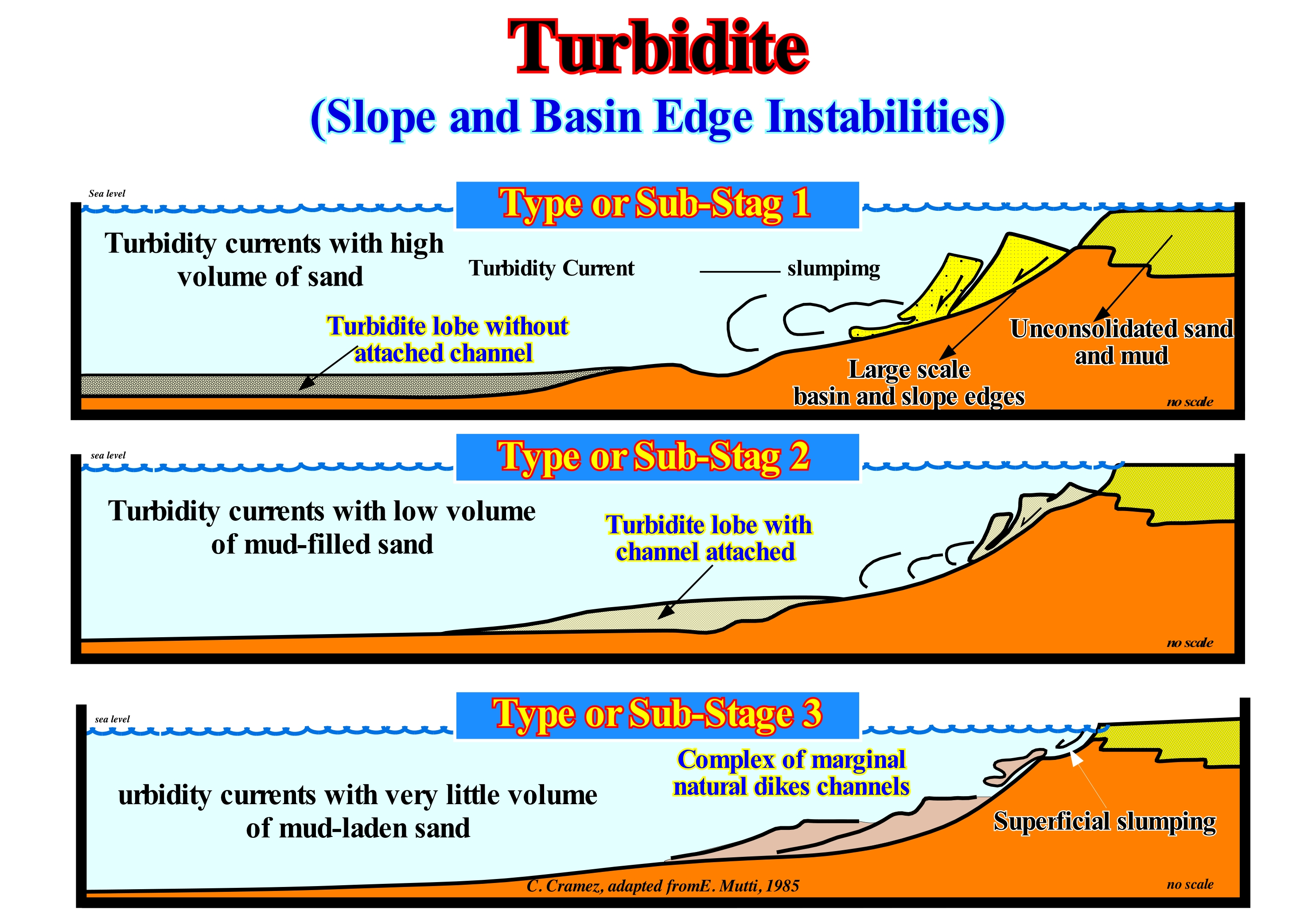
Before the advent of sequential stratigraphy, the turbidites were sedimentary deposits originated by submarine turbidity currents, especially, in the foreland (foredeep) basins, in tectonic contexts of active continental margins and a turbidite is a thinning upward layer or bed (not visible in a seismic line) formed by a a set of sandstone/shale deposited by a turbidity current and covered, usually, by hemipelagic shales containing deep-water fossils. In sequential stratigraphy and, especially, in seismostratigraphy, the turbidite deposits associated with relative sea level falls, that is, with unconformities, are well known to all geoscientists. These turbidites (submarine basin floor fans, SBFF and submarine slope fans, SSF) are deposited under lowstand geological conditions of the relative sea level (local sea level, referenced to any fixed point on the Earth's surface, which can be the base of the sediments or sea floor and which is the result of the combined action of the absolute or eustatic sea level, referenced to the Earth's centre and tectonics), that is to say, that the sea level is lower than the basin edge (at the level of a sequence-cycle, the basin edge, when the basin has no shelf, is the last continental edge of the preceding sequence-cycle). However, according to Emiliano Mutti, in the stratigraphic records, both in the field and in the seismic data, the evidence of turbidite deposits deposited in high-level geological conditions (when the relative sea level is above the basin edge (when the basin has a shelf) is difficult to refute. As illustrated in this figure, this is particularly true for E. Mutti Type-1 turbidites in which the shaly levels are rare and the turbiditic lobes are non-channelized and overlap vertically to form amalgamated deposits. For Emiliano Mutti, there is a relation between the different types of turbidites (Type 1, Type 2 and Type-3) and the volume of gravitational flows. In Type 1, the individual layers (beds) and groups of layers (beds) that occur in a lobe usually reach volumes of the order of 1 and 10 km3. The volume of 10 km3 is of the same order as the volume of sediments of a modern mouth bar of a large delta building (vertical overlapping of deltas). In Type or sub-stage 3, the sandy layers are thin and laterally impersistent. The abundance of fine and very thin silty clay suggests low volume flows with relatively high mud contents. In Type-2 systems, the geometry of sandy turbidic layers suggests intermediate volume flows, generally, with relatively high sand contents. Taking into account the different relative sea level conditions (highstand or lowstand), it can be said that Type-1 turbidites, which are not channelled, correspond, more or less, to submarine basin floor fans (SBFF) of P. Vail when they are detached from the base of the continental slope. In the same way, Type-2 turbidites correspond, more or less, to the submarine slope fans (SSF) deposited at the base of the continental slope, that is, they are, more or less, connected with turbiditic channels. Likewise, Type-3 turbidites are, practically, equivalent to the submarine slope fans (SSF), where the structures in the form of "seagull wings" are characteristic. Type-1 turbidite deposits are, often, referred to as turbiditic lobes without an adjacent channel and located, relatively, far from the rupture of the continental slope base. Turbiditic Type-2 deposits are also known as turbiditic lobes with an adjoining channel and are located near the lower slope of the continental slope. In turn, Type-3 turbidite deposits correspond to channel complexes (or depressions between lobes) and turbidite natural marginal dikes with a gull-wing like geometry and whose location corresponds, more or less, to the continental rise. It is important to note that E. Mutti did not exclude the formation of turbidite deposits in association with significant relative sea level falls, i.e., with unconformities. All Mutti says is that turbidite systems can also be deposited in highstand geological conditions in association with flooding of large rivers or with instabilities of the continental edge or even with failures and landslides of the continental slope. P. Vail considers, unlike E. Mutti, that the development of turbidity currents in highstand geological conditions is insignificant and plays no significant role in the sequence stratigraphy.
(*) Geoscientists call often the sedimentary particles (material that is broken down by processes of weathering and erosion, and is subsequently transported by wind, water , or ice, and / or by gravity acting on the particles) as sediments. We prefer to use the term sediment for a set of deposited sedimentary particles, which can range from the fine dust transported by high-altitude winds to gigantic erratic blocks moved by glaciers formed. In other words, the transported sedimentary particles when deposited form sediments.
Turbiditic Current..................................................................................................................................................................Courant de gravité
Corrente turbidítica / Corriente de turbidez, Corriente turbidítica, Corriente de turbación / Suspensionsstrom, Trübestrom / 当前的浊度 / Гравитационное течение / Corrente torbide, Torbidità corrente /
Very fast current with an important sedimentary load that descends a slope (continental, alluvial or deltaic) through the air, water or other liquid. A turbiditic current moves because it has a higher density and turbidity than the fluid through which it flows. Synonym with Density Current and Turbidity Current.
See: « Turbidity Current »
&
«Turbidite »
&
« Submarine Basin Floor Fan »
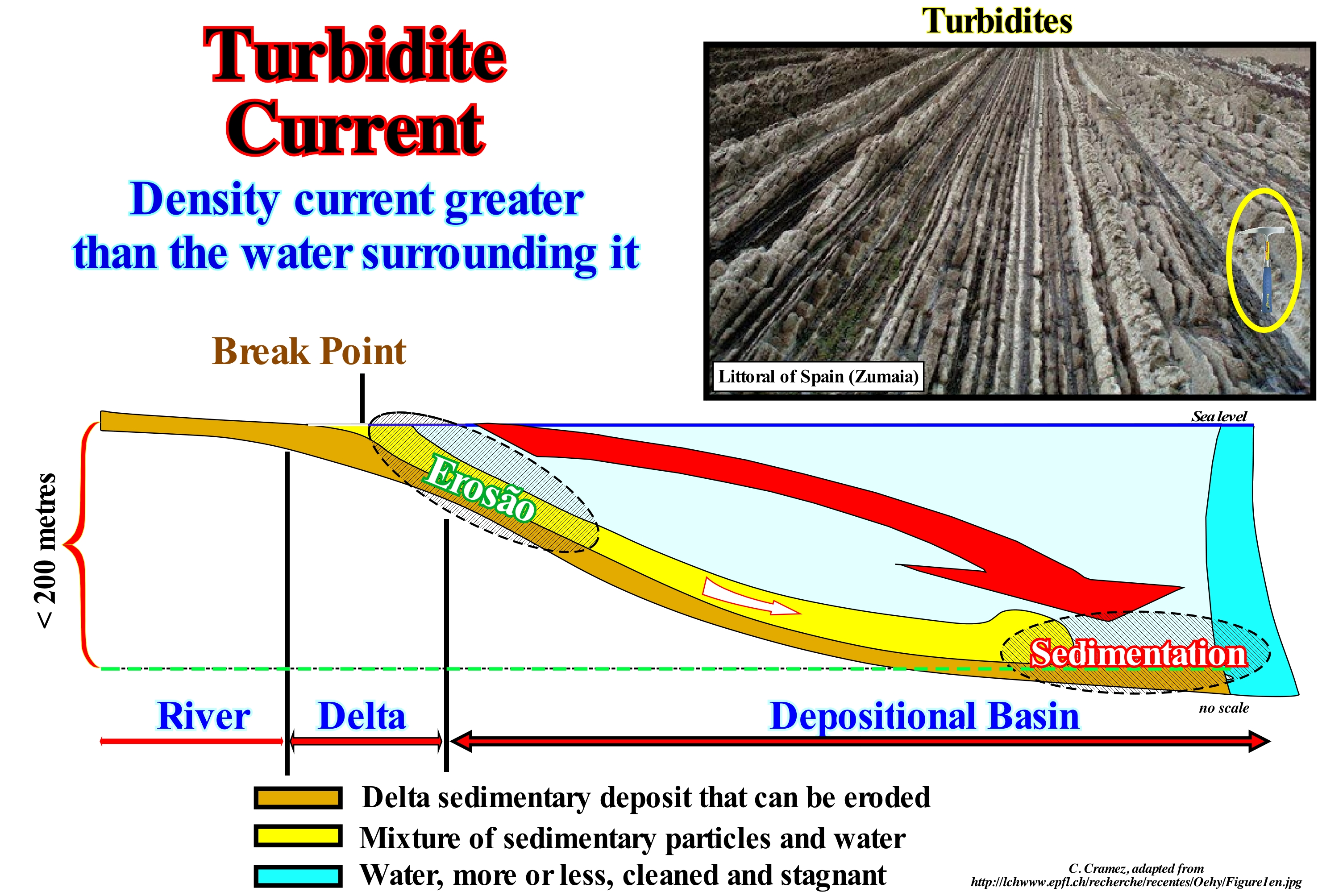
A turbiditic current is one of four types of gravitational sedimentary flows, i.e. a flow of sediments or a mixture of water and sedimentary particle, more or less, horizontal in a gravitational field that is moved by a density difference, without significant influence of the medium existing over that flow. The four types of flow are: (i) Granular Flows, in which the dispersion of the materials and the maintenance of these in suspension is promoted by the collision between particles ; (ii) Liquidated Flows, in which the particles lose contact with each other, being dispersed and kept in suspension by the upward movements of the water ; (iii) Detritic Flows , in which the fluid has a large amount of fine suspended material, which serves as support for the suspension transport of some larger elements and (iv) Turbiditic Flows, which many geoscientists call turbidite currents, which correspond to turbulent mixtures of water and various sedimentary particles which together correspond to a fluid whose overall density is greater than that of the water surrounding the stream. A granular flow (i) produces, often, negatively granulating deposits (the finer particles at the base and the coarser top). A liquefied stream or flow (ii) produces, generally, heterometric deposits (with particles of different sizes). A flow of debris (iii) produces, almost always, massive, heterometric and nongranoclassified deposits. A turbiditic flow (iv) produces positively granulating heterometrical deposits, i.e., that the coarser particles are located at the base and at the top the smallest (coarsening upward). Initiation (trigger) of a turbiditic current requires an exogenous mechanism, which causes a large amount of sedimentary particles to be suspended. In the scheme illustrated in this figure, the turbidite currents are initiated by a delta front failure (not to be confused delta with delta building), when the inclination of the delta slope reaches the critical angle*, that is, when the delta can no longer prograde seaward. Under these conditions, the delta front becomes destabilized and the mass of sediments, suddenly, moves, putting in suspension a large amount of material. The turbidite currents, thus formed, moves to the base of the prodelta (where there is sufficient accommodation). Upon reaching the slope break at the prodelta base, the turbidite current decelerates and loses transport competence, which allows the deposition of proximal submarine turbidite fans. The aggradation of the submarine fans decreases the angle of the delta slope, which becomes, again, stable allowing the delta front to prograde seaward. This sequence of events is easy to recognize on the ground or on seismic lines (aggradation covered by progradation). The geological context is highstand and the turbidites are deposited at the base of the prodelta and not at the base of the continental slope. However, the great turbidite currents. regardless of the initiation factor, flow and develop mainly along the continental slope and when they reach the abyssal plain they deposit, by deceleration, the carried sedimentary particles in the form of submarine fans. In the model of the deposition of the deep-marine turbidites proposed by P. Vail, which is, slightly, different from the model of Emiliano Mutti, the turbidite currents are formed in association with significant fall of the relative sea level (local sea level referenced to a point which can be the sea floor or the base of the sediments, i.e., the top of the continental crust, and which is the result of the combined action of absolute or eustatic sea level, referenced to the Earth's centre and tectonics), which move seaward and downward (negative aggradation) the coastal onlaps. This displacement breaks the provisional equilibrium profile of the rivers, which are forced to deepen their beds to reach a new provisional profile of equilibrium, which greatly increases the terrigeneous influx. The sedimentary particles transported by the rivers are dumped on the continental slope where they trigger turbid currents that move down-slope. Vail distinguished two types of submarine fans induced by this type of turbidite currents: (i) Submarine Basin Floor Fans (SBFF), which geometry is, more or less, sub-horizontal, as illustrated in this photograph by the turbidites of Zumaia (Spain) and (ii) Submarine Slope Fans Slope (SSF), which are, generally, deposited on the submarine basin floor fans and have a typical wavy geometry ("gull-wings" structures).
(*) The critical angle of a delta slope is a function, among other factors, of the water-depth of the continental shelf on which the delta progrades. The higher the water-depth the greater the critical angle.
Turbiditic Flow...........................................................................................................................................................Débit ou Flux turbiditique
Fluxo ou escomento turbidítico / Flujo granular / Turbidit-Strömung / 浊度流 / поток турбидитовых / Flusso torbiditici /
Turbulent mixtures of water and various sedimentary particles* which together correspond to a fluid whose overall density is greater than that of the water surrounding the current.
See: « Turbiditic Current »
(*) Sedimentary particles range from the fine dust transported by high-altitude winds to gigantic erratic blocks moved by glaciers. Generally, the sedimentary particles are subdivided in three large categories: (i) Sand (2–0.063 mm) ; (ii) Silt (0.063–0.004 mm) and (iii) Clay (below 0.004 mm), which leads to a general classification of sediments (deposited sedimentary particles).
Turbiditic System.............................................................................................................................................................Sistème Turbiditique
Systema turbidítico/ Sistema turbidítico / Turbiditen System / 浊积系统 / Система измерения мутности / Torbiditici sistema /
System formed when a significant relative sea level fall or when instabilities of the basin edge produce large scale landslides, which set in motion large amounts of sediments and sedimentary particles (detritus), which are transported over great distances to the deeper parts of the basin and deposited in the form of submarine fans.
See: « Fluvial Deposition »
Turbidity.......................................................................................................................................................................................................................................Turbidité
Turbidez, Turvação/ Turbidez / Trübung, Schlammgehalt / 浊度 / Мутность / Torbidità /
Cloudiness of a fluid caused by large numbers of individual particles that are generally invisible to the naked eye, similar to smoke in air. The measurement of turbidity is a key test of water quality. Often synonymous with Turbidness.
See: « Turbidity Current »
Turbidity Current (Turbidite)................................................................................................................................Courant de turbidité
Corrente de turbidez / Corriente de turbidez, Corriente turbidítica, Corriente de turbación / Suspensionsstrom, Trübestrom / 当前的浊度 / Мутьевое течение / Corrente torbide /
Current (air, water, or other fluid) caused by differences in quantity and quality of the suspended material (mud, silt, etc.). Marine turbidity currents, which carry suspended sediments, rapidly move down the continental slope and then spread on the abyssal plain. Synonym with Turbidity Current. and Turbidness Current.
See: « Stream»
&
«Turbidite »
&
« Lowstand Prograding Wedge »
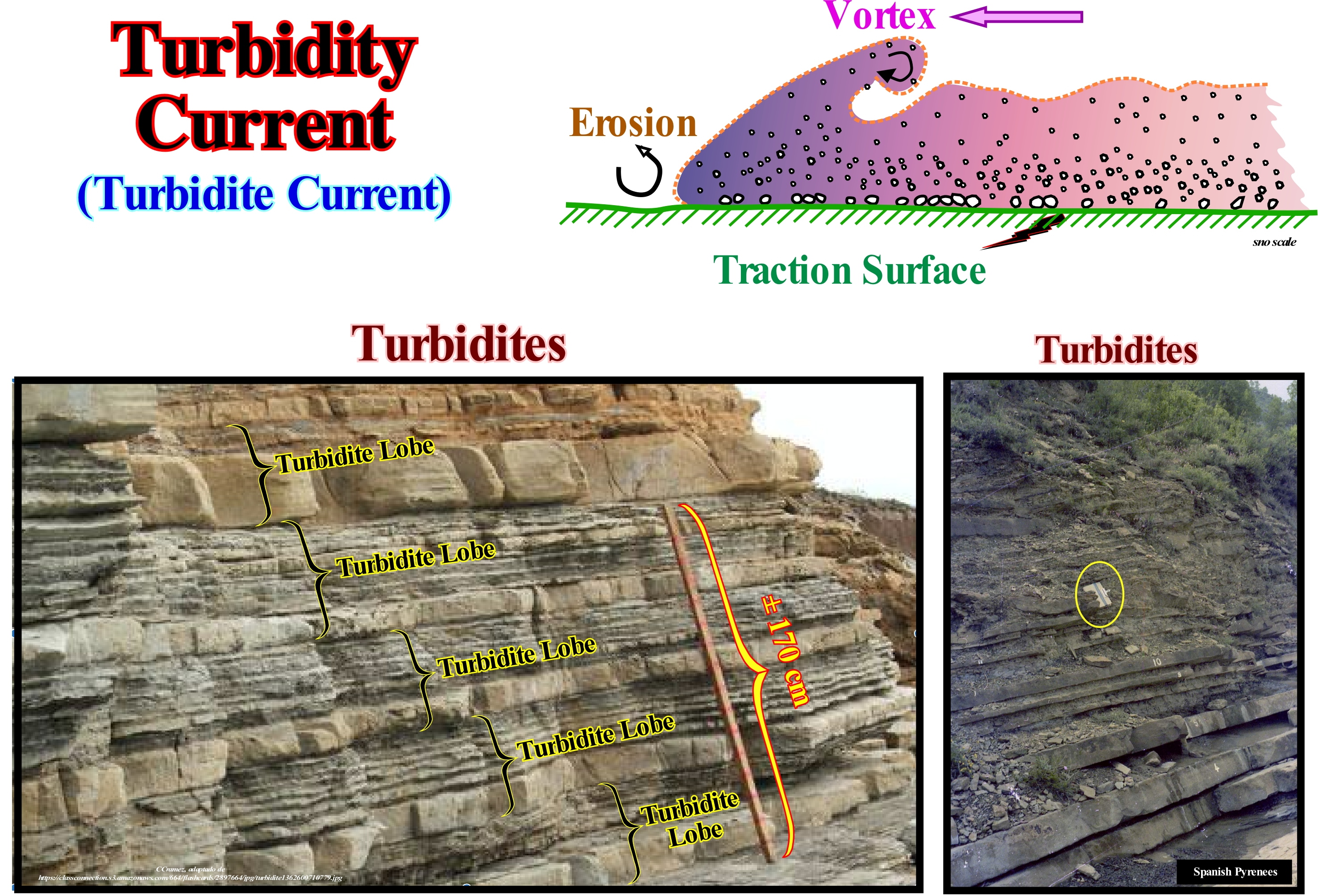
A turbidite stream or current is a gravity stream or current of density (flow, more or less horizontal in a gravitational field that is moved by a density difference) of strong density which, generally, originates in areas with a substantial deposition. This transport mechanism occurs in a mixture of water and sedimentary particles moving along the bottom sea because the density of the mixture is greater than that of the water-body in which it flows and is, generally, created by turbulence between the grains (irregular movement of a fluid in such a way that the velocity of the different fluid particles passing at one point may vary with time in magnitude and direction). The turbulence generates upward-directed forces, which keeps the turbidity current materials in constant suspension. On the other hand, by this mechanism a current of turbidity can go through dozens, to see, hundreds of kilometers because of the erosive capacity of the mechanism, which tends to increase the load of suspended materials which necessarily increases its viscosity. Although, the reasons for the formation of a turbidity stream, that is, although the factors that puts the sedimentary particles suspended in the water, can be very varied (earthquakes, increased sedimentation, floods of rivers, topographic survey, descent of sea level, rupture or increase of slope, etc.) a turbidity current always develops in continental slopes with great dip. When, within a sequence-cycle (a stratigraphic cycle induced by a 3rd order eustatic cycle, which means that it has a time-duration between 0.5 and 3-5 million years), the sedimentary basin has no continental shelf (the depositional coastal break of the deposition surface roughly corresponding to the shoreline and coincides with the continental edge), as the front of a delta, for instance, progrades seaward, the angle of the slope, which is, in this case located at the top of the continental slope, increases until reaching a critical angle. When this angle is exceeded the mass of sediments becomes unstable and suddenly moves putting in suspension a large amount of sedimentary particles. The force of this type of current is very great and causes the entrainment of all the material that is found ahead, modeling a great part of the submarine canyons. However, since the current loses its energy by finding a significant slope break (usually at the foot of the continental slope or the abyssal plain), it slows down sufficiently for the sedimentary particles deposit in the form of submarine fans (as illustrated in this photograph) that form the most important turbidite depositional systems. Most of the material is transported by the mechanism outlined in this figure. On the front there is erosion by aspiration and deposition in the back. Large blocks move by traction either by traction (crawling of sediments over the interface between sediment and fluid) or by rolling (rotation of sedimentary particles around the shaft itself over the interface between sediment and fluid), at the base of the stream, while the smaller particles remain in suspension. They can travel hundreds of miles at relatively large speeds (tens of kilometers per hour). They are formed either in geological situations of highstand (relative sea level above the basin edge) or of lowstand (relative sea level lower than the basin edge), when the basin has no shelf. In the first case, they are formed by landslides created by instabilities or failures of the basin edge, or during the floods of the rivers that carry seaward an excess of sedimentary particles, that can not be deposited in the platform or in coastal plain. In the second case, they are associated with significant falls of the relative sea level (referenced to the sea floor or to the base of the sediments), which exhume the continental shelf, if there is one, and the upper part of the continental slope. The river-mouths are, sometimes, displaced seaward several tens of kilometers. The material transported by the rivers will fall directly on the continental slope and is transported by turbidity currents to the deeper parts of the basin where it is deposited. In the first case, the deposits may have any age, within a sequence-cycle, whereas in the second case, they have the age of the relative sea level fall, that is, the age of the associated unconformity.
Turbidness Current (Turbidity current)..............................................................................................Courant turbiditique
Corrente de turvação / Corriente de turbidez / Trübung Strömung / 浊流 / Турбидитное течение / Torbidità corrente /
Current (air, water, or other fluid) caused by differences in quantity and quality of the suspended material (mud, silt, etc.). Marine turbidity currents, which carry suspended sediments, rapidly move down the continental slope and then spread on the abyssal plain. Synonym with Turbidity Current. and Turbiditic Current.
See: « Stream»
&
«Turbidite »
&
« Lowstand Prograding Wedge »
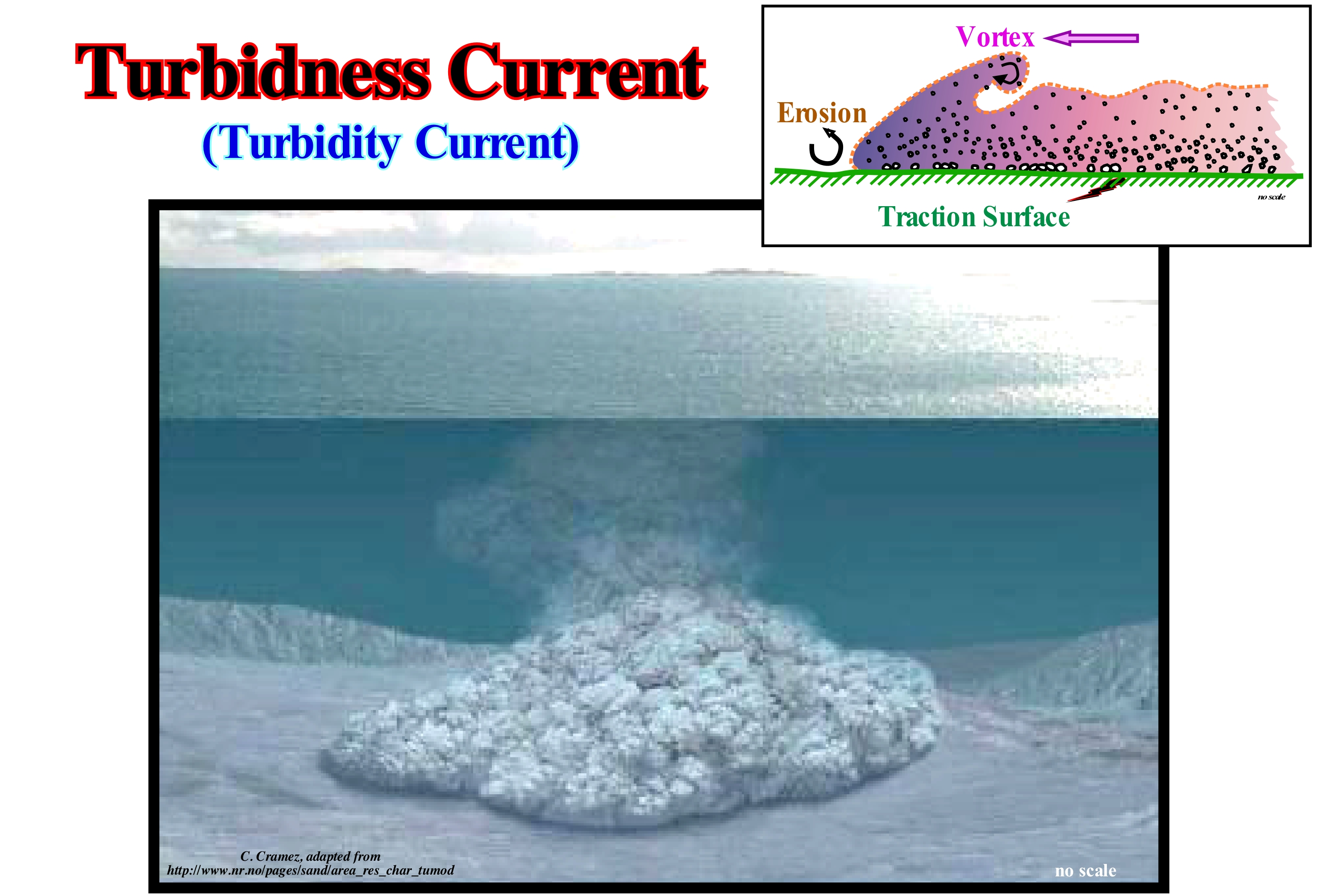
Turbidity currents result from very rapid movement of bodies of water (pelitic and fine sandy) in colloidal suspension and, or swirling, along the continental slope or protruding reliefs of the ocean floor. For some geoscientists, the burden of these currents comes from the sea floor shaking by earthquakes, volcanoes or explosions. For others, it comes from river sedimentary particles carried seaward during periods of large river floods (E. Mutti) or during significant relative sea level falls that produce an exhumation of the shelf (if any) or top of the continental slope (P. Vail). The importance of the morphogenic potential of these currents varies with the geological conditions and, of course, also with the geoscientists. They are, sometimes, considered as powerful erosive agents of the continental slope, where they contribute to the shaping of the slopes of the submarine canyons, which means they are the very agents of the excavation of the canyons. However, this is not a general rule. These hypotheses have been advanced only from the bathymetry of the zones that these currents use to move to the sea floor. Many geological interpretations of the seismic lines drawn in such regions strongly suggest that bathymetry is not the result of an erosive action of the currents, but rather that it is built, progressively, by depositing from the of overflow induced by currents. Often, what many geoscientists call the canyon created by the turbidity currents is the canyon that the river, which is upstream of the canyon, dug during a lowstand period. In other cases (when there is no river up-dip of a canyon), the canyon is mainly created by the erosive action of an upwelling current, which preceded and conditioned the place of passage of turbidity currents.
Turbulent Flow....................................................................................................................................................................Écoulement turbulent
Escoamento Turbulento / Flujo turbulento / Turbulente Strömung / 湍流 / Турбулентный поток / Regime turbolento, Flusso turbolento /
Flow of a fluid in which the flow lines are confused and mixed. The fluid sometimes moves back and forth in swirls. Synonym with Turbulent Flow.
See: « Flux (flow) »
&
« Lahar »
&
« Turbidity Current »
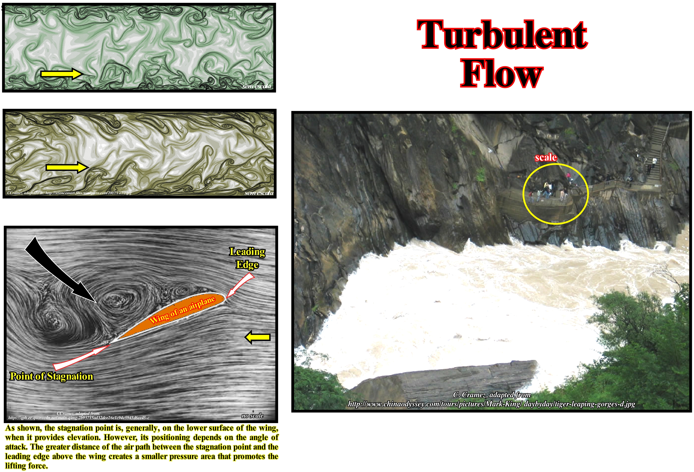
In fluid mechanics a turbulent flow is a fluid regime characterized by changes in chaotic and stochastic properties. Generally, in the human body, the blood moves in a laminar manner. However, under certain conditions of strong flow, particularly in the ascent to the aorta, the laminar flow may disappear and become turbulent. When this happens, the blood does not flow in a linear and smooth manner, but instead flows in a chaotic manner as the flow of water into the mountain stream illustrated in this figure. The turbulent flow may also occur in the large arteries near the branching points. In the human body, turbulent flow increases the energy required for blood circulation because turbulence increases the loss of energy in the form of friction. Turbulence only begins when the flow velocity is sufficiently high to destroy the laminar flow. Turbulence occurs when the Reynolds number is reached. Mathematically, the Reynolds number can be defined by Re (ρ u2) / (μu/L) = ρu L/μ = uL /v, where Re = Reynolds number (without dimensions), ρ = density ( (kg/m3), u= (m / s), μ = dynamic viscosity (Ns/m2), L = length (m) v = kinematic viscosity (m2/s). This number is used to determine if the flow is laminar or turbulent (as, for example, in oil pipelines). Thus, the flow is laminar, when Re is less than 2,300, and turbulent when Re is greater than 4,000. If Re is between 2,300 and 4,000, the flow is said to be transient (both flows are possible). In rivers and mountain streams a turbulent flow allows the sedimentary particles to be suspended for longer than a laminar flow and evidently reinforces erosion at the base of the stream. The average linear velocity is, generally, higher in a laminar flow than in a turbulent flow. Recently, some geoscientists have advanced the hypothesis that the turbulent flow affects, greatly, the fish behaviour in the rivers. The flow of the rivers can be related to the flow of a turbulent horizon. In the turbulent flow the velocity of the fluid at any point is continuously changing both in direction and in magnitude. Bearing this in mind, the flow of the winds and rivers is, generally, turbulent, even though the currents are, relatively, smooth. The air and the water swirl and swirl, although, globally, the whole volume flows along a specific direction. Most types of fluid flow are turbulent, except for the laminar flow at the ends of the solids, which moves, relatively, to fluids or very close to solid surfaces, such as in the inner wall of a tube, or in the cases of fluids with high viscosity, that flow slowly through small channels. As common examples of turbulent flows we can cite: (i) Blood flow in the arteries ; (ii) The transport of oil in pipelines ; (iii) The lava flow ; (iv) Atmosphere and ocean currents; (v) Flow through pumps and turbines ; (vi) The flow around a boat or the wings of an airplane, etc. For many geoscientists the notion of turbulence is associated with a turbulent flow composed of "swirls" of different sizes. The different sizes define a characteristic length scale for the swirls, which are also characterized by the speed and time scales (rotation time), which depends on the length scale. Large swirls or vortices are unstable and eventually break apart by creating smaller swirls, and the kinetic energy of the initial large swirls is divided by the small swirls that resulted from them. These little swirls undergo the same process and give rise to even smaller swirls that inherit the energy of their predecessors and so on. In this way energy is transmitted from the large-scale scales to smaller scales until a scale of sufficiently small length is reached such that the viscosity of the fluid can effectively dissipate the kinetic energy into internal energy.
Type I Unconformity.......................................................................................................................................................Discordance type I
Discordância de tipo I / Discordancia de tipo I / Typ I Diskordanz / 整合I型, 键入我不整合 / Несогласие типа I / Discordanza di tipo I /
Erosional surface induced by a relative sea level fall (tectonic plus eustasy) that set the sea level lower than the basin edge (when the basin has a shelf, i.e., in highstand geological conditions). In the deep parts of the basin, where there is, practically, no erosion, a type I unconformity becomes a correlative paraconformity. Submarine basin floor fans (SBFF) and slope fans (SFF) are deposited in association with this type of unconformity.
See: « Unconformity »
&
« Type II Unconformity »
&
« Relative Sea Level Fall »
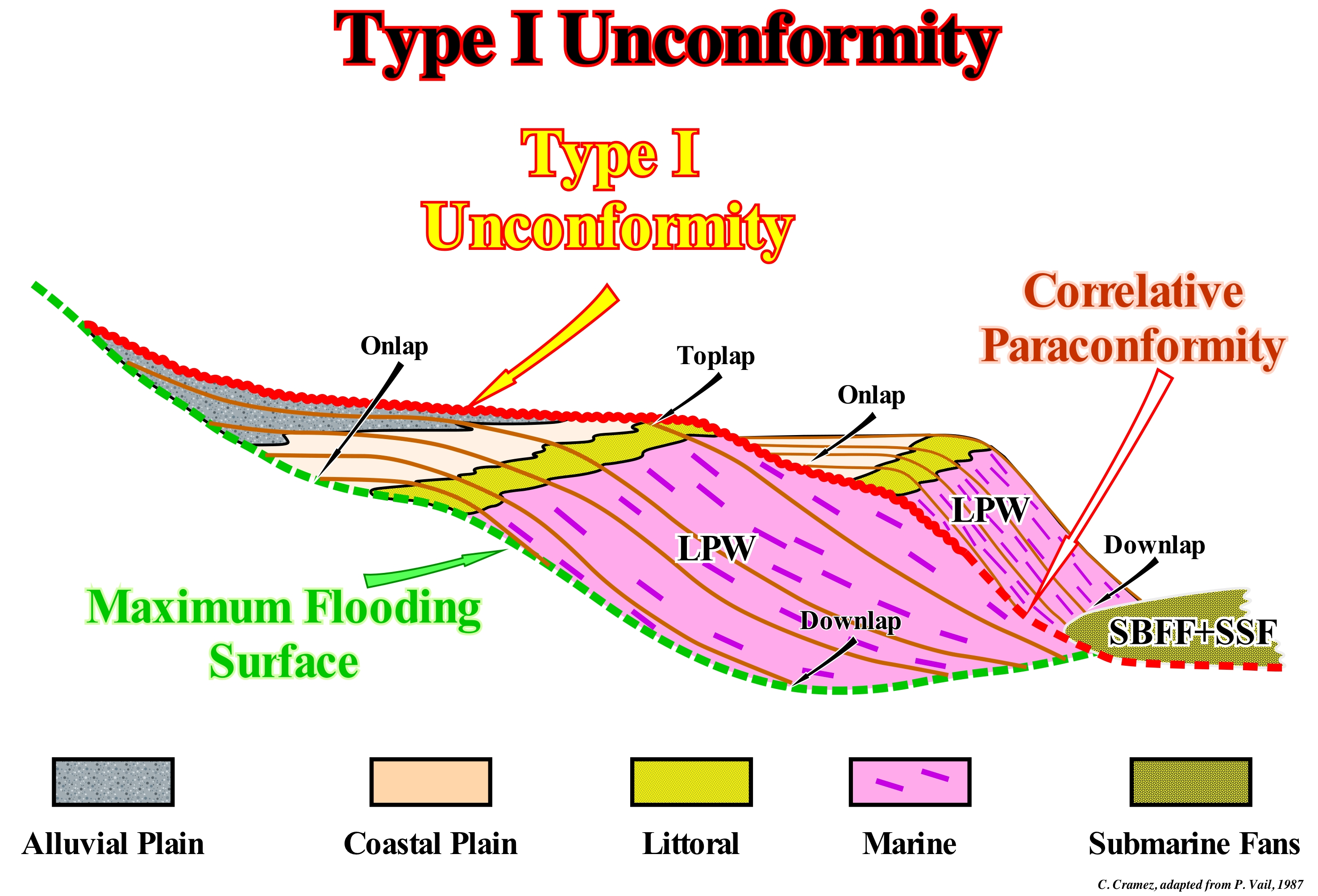
In this scheme, a Type I unconformity separates two sequence-cycles (stratigraphic cycles induced by a 3rd order eustatic cycle, i.e. cycles with a time-duration between 0.5 My and 3-5 My). It is characterized not only by the onlapping of overlying sediments, but also by the toplaps (by erosion or non-deposition) of the underlying sediments. The lower sequence-cycle is incomplete. It is represented only by the highstand systems tracts group (HSTG) which forms the progradational subgroup, i.e., the highstand prograding wedge (HPW), which at the base is limited by the flooding surface (green coloured dashed line) that limits it from the retrogradational lower subgroup, that is, the transgressive interval (TI) that is not represented in this scheme. Within the highstand prograding wedge (HPW), chronostratigraphic lines have a sigmoid geometry. In this sketch, it is easy to see that each of the sequence-paracycles that form the highstand prograding wedge (HPW) corresponds to a sedimentary systems tracts along which different depositional systems characterized by a lithology with a fauna, more or less, typical deposited in a given sedimentary environment. Also, it is not difficult to verify that the chronostratigraphic lines intersect the facies lines (lithology) defined by the same lithology of the different sequence-paracycles. Thus, in the highstand prograding wedge (HPW) of the lower sequence-cycle, different depositional systems with lithology and sedimentary environments can be highlighted, which from the continent seaward are: (i) Alluvial Plain (often, the topography of the coastal plains of the rivers has the form of a fan, which means that the bed of the river can move, easily, flooding areas, relatively, far from the main bed) ; (ii) Coastal Plain (associated with a set of factors such as relative sea level changes, coastal drifting currents, juxtaposition of littoral barriers bars, etc.) ; (iii) Littoral (portion of the marine region that covers the area affected by the high-tide and low-tide) and (iv) Marine. During the highstand prograding wedge (HPW), which is deposited when the relative sea level* is decelerating (there are no relative sea level fall between eustatic paracycles), the basin edge, which initially did not coincide with the shoreline (the basin had a shelf) from one determined, when the basin edge was, more or less, coincident with the shoreline, the basin has continental shelf. Since the relative sea level stopped rising and began to descend, the coastal plain was, relatively, lifted and the upper part of the continental slope was exhumed creating an erosion surface, that is a Type I unconformity. Erosion has, dramatically, increased the terrigeneous influx, which, since it reaches the continental slope, is carried by gravity to the sea floor, where the sedimentary particles are deposited in the form of submarine basin or slope fans (sedimentary intervals deposited during significant of relative sea level falls), thus beginning a new sequence-cycle. As long as the relative level of the sea begins to rise, the coastal onlaps, gradually, fossilize a Type I unconformity. The upper sequence-cycle is also incomplete. However, unlike the lower sequence-cycle, it is only constituted by the sedimentary systems tracts subgroups that form the lowstand systems tracts group, namely: (i) Submarine basin floor fans (SBFF) ; (ii) Submarine slope fans (SSF) and (iii) Lowstand prograding wedge (LPW). The former are, easily, recognized by their aggradation pleasing geometry. The submarine slope fan, which in this sketch are grouped with the submarine basin floor fans, are recognized, mainly in the seismic lines by the gull-wings structures, whereas the lowstand prograding wedge is, easily, recognized, by its progradational geometry. To conclude, it can be said that with Type I unconformity, there are, always, associated, in the deep basin, submarine basin floor and slope fans, which is not the case in Type II unconformities, as can be seen in the geological sketch shown in the next figure.
(*) Local sea level, referenced to any point on the Earth's surface, which may be the sea floor and the base of the sediments, which is the result of the combined action of absolute sea level, which is supposed to be global and referenced to the Earth's centre and of tectonics.
Type II Unconformity....................................................................................................................................Discordance Type II
Discordância de tipo II / Discordancia de tipo II / Typ II Diskordanz / 二,不整合型, 不整合型II / Несогласие типа II / Discordanza di tipo I /
Erosional surface created by a relative sea level fall that did not set the sea level lower than the basin edge (when the basin has a shelf, i.e., in highstand geological conditions). Only part of the platform or the coastal plain is exhumed, which means that the upper continental slope is under water. As in a type I unconformity, downstream a type II unconformity becomes a correlative paraconformity. In the deep part of the basin, there are no submarine fans associated with a type II unconformity. At present, geoscientists no longer consider this kind of unconformity. They prefer to talk about forced regressions.
See: « Unconformity »
&
« Type I Unconformity »
&
« Relative Sea Level Fall »
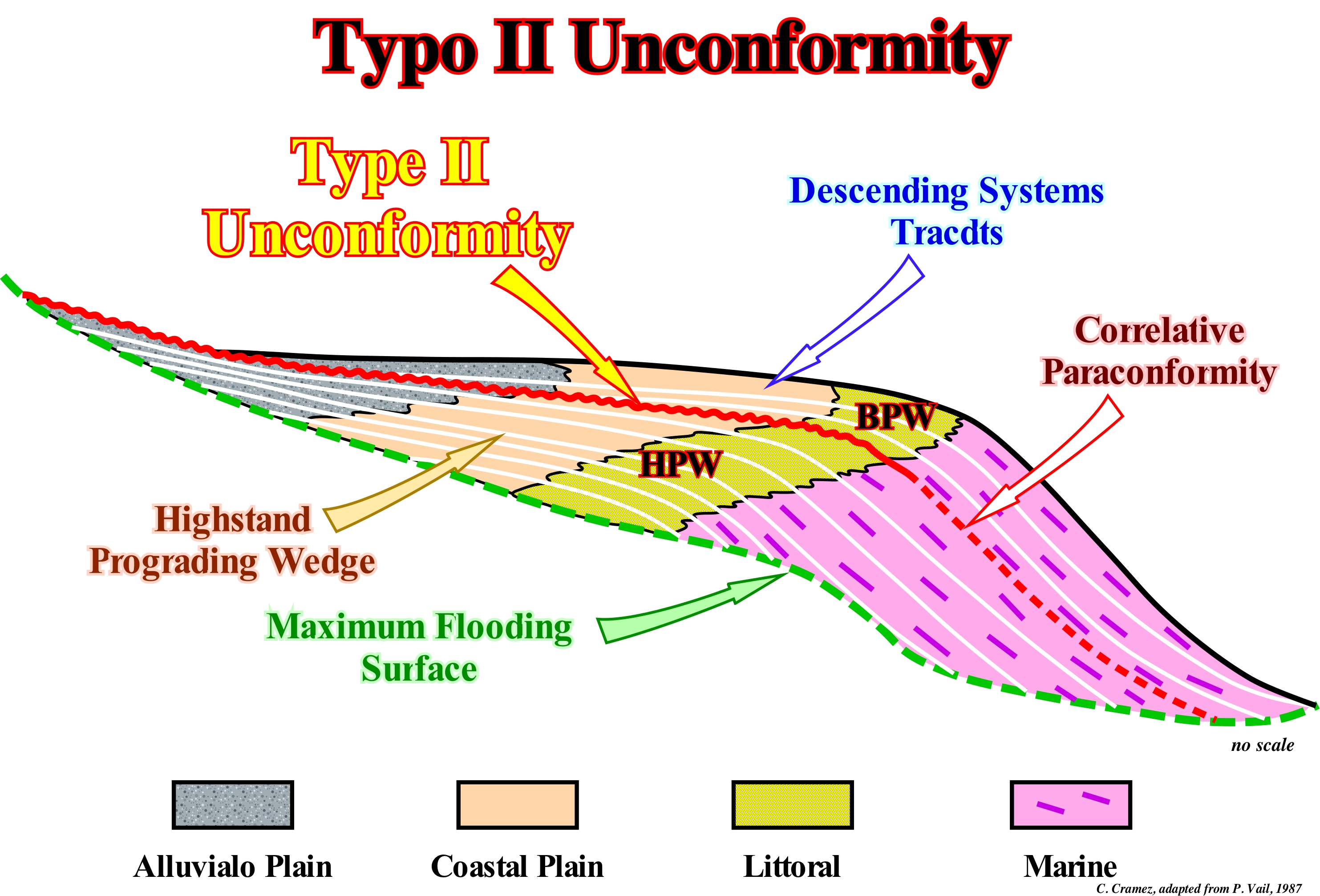
This type of unconformity, which has now, virtually, disappeared from the terminology of sequential stratigraphy (nowadays geoscientists speak, mainly, in forced regressions) does not limit a stratigraphic cycle, since the fall of the relative sea level (local sea level referenced to any point on the Earth's surface, which may be the sea floor or the base of the sediments, and which is the result of the combined action of the absolute sea level, which is supposed to be global and referenced to the Earth's centre, and tectonics) to which it is associated is not important enough to individualize an eustatic cycle: the relative sea level is not lower than the basin edge, which means that geological conditions remain highstand. In this sketch, at the hierarchical level of a sequence-cycle, a highstand prograding wedge (HPW) is shown, which is deposited above the maximum flooding surface, which individualizes it from the underlying transgressive interval (not shown in the sketch). In the highstand prograding wedge (HPW), bedding planes or reflectors (in the case of a seismic line) are sigmoid and intersect the facies lines defined by the lithologies of the different depositional systems of the sequence-paracycles. As the relative sea level rise in deceleration (increasingly smaller marine ingressions), the associated sedimentary regressions move the shoreline (which is probably very close to the basin edge) seaward (progradation, outbuilding) and upward (aggradation, upbuilding). However, progradation is, largely, preponderant. From a certain moment, the relative sea level no longer rises in deceleration and begins to fall slowly, exhuming just part of the continental platform, before stabilizing or even rising slightly. This small falling of the relative sea level creates a Type II unconformity, which means that it causes a small seaward and downward of the coastal onlaps but they do not reach the continental slope. The sedimentary interval deposited between a Type II unconformity and the following Type I unconformity, induced by a significant relative sea level, forms what certain geoscientists call "descending systems tract subgroup" or Bordering Prograding Wedge (BPW), which, for P. Vail, is or was an integral part of the underlying sequence-cycle*. In this model, it is easy to see that the chronostratigraphic lines (seismic reflectors) cut the facies lines that, from the continent to the sea, delimit different depositional systems: (i) Coarse sand and silts deposited in an alluvial plain ; (ii) Fine sand and shales deposited on a coastal plain ; (iii) Coastal sands (usually deposited in front of delta) ; (iv) Shales deposited on the slope of a delta or on the continental slope, since this geological scheme has no scale**. During the highstand prograding wedge (HPW) of a sequence-cycle, the basin edge and the shoreline are well individualized at the beginning of this sub-group of systems tracts (1st stage of the development of the highstand prograding wedge) but, progressively, as the relative sea level rise is in deceleration, the shoreline approaches the basin edge, reducing the extent of the shelf. From a certain point the shoreline becomes the continental edge, since the basin no longer has a shelf (2nd stage of development of the highstand prograding wedge), which means that the shoreline coincides, roughly, with the basin edge, which marks the top of the continental slope. In this case, the slope of a delta rests, directly, on top of the continental slope.
(*) At present-time, most geoscientists consider that such unconformity is an integral part of the sequence-cycle and they speak either in descending systems tracts (P. Vail) or forced regression, which they define as a seaward displacement of shoreline within of a sequence-cycle, when the relative sea level falls and when the position of the upper limit of the sequence-cycle, is difficult to locate. For some years now, there has been an important debate regarding the position of the upper limit of the sequence-cycle in the transitions marine to non-marine environments.
(**) All geological interpretation depends on the scale, which means that without a scale, a geoscientist can not decide if a slope is a continental slope (height over 200 meters) or a delta slope (usually between 20 and 50 meters). On the other hand, it can also be said that the geological interpretation and, particularly, the interpretation of the seismic lines also depend not only on the knowledge of the geoscientist but also on its expectations and that therefore the location of the data is fundamental. If a seismic line, for example, comes from a divergent margin or converging margin, the geoscientist naturally expects to identify very different things.

